


This past weekend, a wave of severe storms have swept across the Central US, putting an estimated 46 million people at risk, according to NBC News. The path of destruction from these storms has spanned from Texas to Michigan, with states such as Kansas, Nebraska, Iowa, and Missouri taking the brunt of tornadoes, hailstorms, and flooding, resulting in major infrastructure damage across several regions of the Great Plains. One of the biggest contributors to this outbreak of extreme weather has been the formation of supercell storms, the rarest and most dangerous type of thunderstorm. Now that the storm has begun to cool off, here’s what you need to know about one of the biggest weather events of the year so far.
What are Supercell Storms?
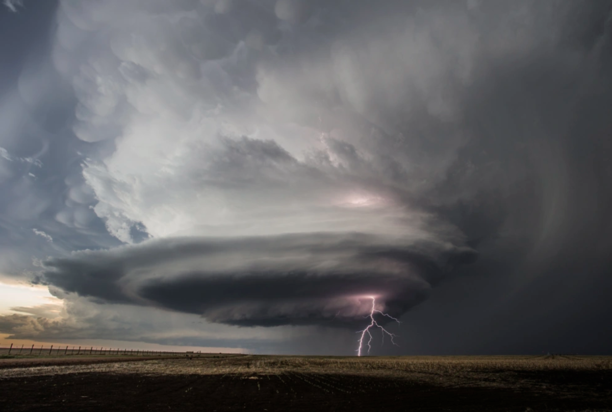
Thunderstorms are usually classified into two main categories: single-cell and multi-cell storms. According to CNN, supercell storms are considered single-cell storms because they are created from a single updraft and downdraft. In contrast, when multiple updrafts and downdrafts from different storms cluster together, they form a multi-cell storm. Supercell storms have several groups based on environment: low-precipitation, high-precipitation, and classic, with the latter being the most common. Unlike most single-cell storms, which tend to be weak and short-lived, supercell storms are much more powerful and, under the right conditions, can last for hours, according to The Weather Channel.
The reason supercell storms are so dangerous is because of their mesocyclone, the most important and distinct feature that distinguishes them from all other thunderstorms. Exclusive to only supercell storms, the mesocyclone begins to form in the lower atmosphere when wind shears, air currents that change in speed and direction with increasing height, are present in the environment. Importantly, they generate something called horizontal vorticity, which is the rotation of air around a horizontal axis. Think of it as a tube made up of spinning air. According to The Weather Channel, when strong updrafts from a thunderstorm encounter this spinning air, they vertically tilt the horizontal vorticity, creating a strong column of rotating winds. As it stretches upward, the spin increases, helping the storm pick up moisture and energy, keeping the updraft going.
When they get going, supercell storms are among the most destructive weather events. After it forms, a typical mesocyclone stretches 10 miles wide and 50,000 ft tall according to NOAA. This immense size leads to strong updrafts and downdrafts, many of which can exceed 100 mph. The powerful, fast winds produced by supercell storms create the perfect conditions for tornadoes to form. When they are spawned, these tornadoes can last for hours, according to The Weather Channel. Additionally, when measured on the Enhanced Fujita Scale (EF), the scale for tornado intensity, those created by supercell storms are often ranked higher. This is because, as the mesocyclone grows, the tornadoes it produces are fueled by the energy the storm draws from the environment, allowing stronger winds to form. According to NOAA, along with tornadoes, supercell storms can also produce severe hailstorms, with hailstones larger than golf balls, and flash floods, due to heavy rain.
How has the Storm Affected the Central US?
Over the last few days, multiple states across the Central US have been affected by serious weather. Thunderstorms that developed across the Great Plains on Saturday have produced powerful winds, large hail, and frequent lightning. While initial forecasts suggested only limited risks of tornadoes and flooding, meteorologists warned that many of these storms would strengthen into dangerous supercells in the coming days, according to The New York Times.
By Sunday, the storm had intensified even further, with multiple supercell storms observed. As a result, there were hundreds of severe weather reports across the region. According to USA Today, at least 123 hail incidents and 180 damaging wind reports were reported. The strongest tornadoes seen reached EF3 intensity, hitting several states, including Kansas, Missouri, Nebraska, and Iowa, according to CNN. Additionally, many areas of the Great Plains experienced tornadoes ranging from EF1 to EF3, and heavy rainfall heightened the risk of flash flooding in states such as Missouri.
Monday was when the storm was predicted to be at its strongest, with the highest risk of developing large supercell storms. The New York Times reported that winds reached up to 75 miles per hour and hailstones were as large as 4 inches across. As the storm moved through the region, heavy rain, lightning, and hail became more frequent, causing widespread damage. Along with this, wildfires have broken out across parts of New Mexico, Texas, and Oklahoma due to the low humidity and winds created by these supercell storms. Across multiple states, a combined 200,000 acres of land has been burned down.
Now that the storm has passed, these states have shifted their focus to rebuilding from the damage. Widespread flooding and tornadoes have left many homes, businesses, and farmlands in ruins. For many citizens, however, these annual storms are a familiar challenge of life in “tornado alley.” More than anyone, they know how to rebound from such disasters, and hopefully, many of these impacted communities can make a quick recovery.